需要我們的協助嗎?

By Iliya Shofman
UTAT Space Systems, Optics Lead
The future depends on sustainable, data-driven agricultural practices.
The University of Toronto Aerospace Team (UTAT) is an undergraduate student design team that is building an Earth-observation CubeSat called “FINCH” – which stands for “Field Imaging Nanosatellite for Crop residue Hyperspectral mapping”. Measuring just 10x10x30cm, FINCH will carry a SWIR-range hyperspectral imaging payload developed in-house from a combination of custom and commercial optics. Edmund Optics® is supporting UTAT by providing some of their TECHSPEC® SWIR imaging lenses.
Hyperspectral Earth observation is a powerful imaging modality that helps researchers and farmers monitor crop health, conserve natural resources, and perform a variety of other ecological studies. The University of Toronto Aerospace Team (UTAT) is building a hyperspectral imaging nanosatellite that would cost ~1000 times less than state-of-the-art satellites yet deliver a good-enough imaging quality and fulfil a “sensing gap” that would help farmers implement sustainable agriculture practices. UTAT is currently building a prototype of their hyperspectral imaging payload using Edmund Optics SWIR lenses and is working towards a qualification testing campaign.
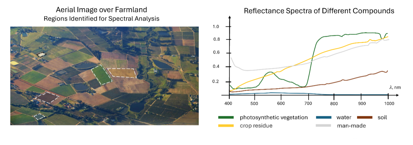
When we think of satellite imagery, the first thing that comes to mind is Google Earth. While rich in geo-spatial information, these simple RGB images don’t tell the full story of what’s happening on the ground. Instead, multi-spectral imaging sensors can be used to collect panchromatic images with a dozen wavelength bands, which can help distinguish and classify materials on the ground. However, for accurate quantitative measurements and challenging material identification problems, even finer spectral resolution is required. Hyperspectral imagers are used in applications where precise spectral information is needed for every “pixel” in an image, and unlock a wealth of information beyond what’s possible with regular and multi-spectral sensors. For example, the pond in the bottom right corner in Figure 1 could be mistaken for a small farm field on an aerial image, yet can be clearly distinguished when spectral information is available.
Hyperspectral Earth-observation remote sensing is crucial in climate science and sustainable agriculture applications 2, 3. Unlike laborious aerial surveys with drones or aircraft, satellites can collect data over almost the entire Earth’s surface with little operating cost once they are launched. While existing satellites deliver high quality hyperspectral data, they can revisit a ground target only once every few weeks and are therefore limited in coverage. The unique advantage of nanosatellites is that they are much cheaper to build and can be deployed in large numbers to provide daily coverage of the entire world’s land surface. However, squeezing a capable optical system into a small nanosatellite form factor is challenging.
With the FINCH mission, UTAT is focusing on measuring the distribution of crop residue over agricultural farmland. Crop residue is the biomass that gets left behind after a harvest has been made – farmers often leave it to decompose to recycle nutrients back into the soil 4. But finding the right balance is key – leaving behind too much crop residue could result in the soil harboring pests and pathogens, while leaving behind too little makes the farmland susceptible to erosion 5, 6.
The short-wave infrared (SWIR) wavelength range spans 900nm to 1700nm, and contains information that isn’t accessible within the visible and near-infrared. Absorption at certain wavelengths within this range can be correlated to plant water content, nitrogen levels, as well as lignin and cellulose levels – metrics that are important to agriculture and forest management. Data from the SWIR range complements and augments measurements taken in the visible range, and in tandem can yield valuable insights for conservation, climate science, and agriculture business.
Spectral unmixing techniques can be applied to quantify the fractional abundance of crop residue. However, for the results to be accurate, very fine spectral resolution and good signal-to-noise ratio (SNR) are needed. Additionally, it is desired that the satellite collects data over a wide field of view with a practicable spatial resolution. These requirements drive the design of the FINCH EYE hyperspectral imaging system, which aims to deliver 3nm spectral resolution over 900-1700nm with a 50km ground swath width and 100m spatial resolution.
For comparison, the latest state-of-the-art hyperspectral imaging satellites such as PRISMA and EnMAP offer 30m spatial resolution, 30km swath width, and 10nm spectral resolution in the SWIR range 7 8. While volume constraints on FINCH make it difficult to attain a fine spatial resolution, a carefully-built spectral engine can yield improved spectral resolution and field of view. The latter advantage will allow FINCH to fly over ground target sites more frequently and study transient events – such as planting and harvest season – with greater temporal resolution.
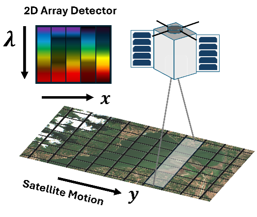
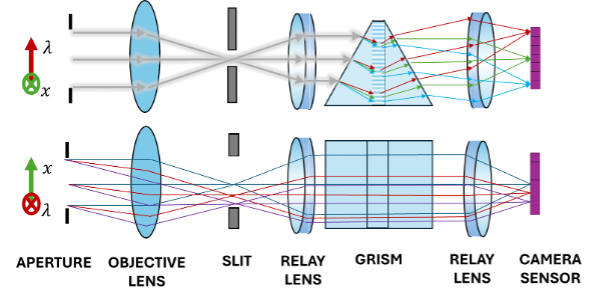
FINCH EYE employs a push-broom hyperspectral imaging architecture, as illustrated in Figure 2. In this approach, the satellite images a single stripe on the Earth’s surface and disperses light into its spectral components along the perpendicular axis of the camera sensor. The satellite scans across the Earth’s surface as it orbits, thus acquiring a hyperspectral “datacube” with two spatial axes and one spectral axis of information. Within FINCH EYE, this is implemented with a commercial objective lens that images the Earth, a slit which “selects” one stripe on the ground, and a dispersive lens – grating – lens relay that reimages light from the slit onto the camera sensor.
Developing an optical system is not an easy task as there are many engineering trade-offs to be made. In nanosatellites, volume and mass come at a premium – the design must be compact yet robust enough to withstand launch vibrations. Another key consideration is cost – a custom-designed optical system would perform “perfectly” but also cost a fortune. Moreover, as an undergraduate student team, we have limited time to work on this project since we must also attend lectures and write midterms.
Using a combination of custom and commercially-available optics, we found it is possible to create a system that is “good enough” – it satisfies our scientific and mission objectives – with the added benefit of relying on a trusted and widely-used product.
Edmund Optics sponsored UTAT and generously provided TECHSPEC® SWIR lenses for our hyperspectral imaging system. These lenses are used to image the Earth and then transmit light through a dispersive relay to produce the hyperspectral images. Some Edmund Optics lenses have space-flight heritage 9, which supports our confidence in the quality of their design and manufacturing.
As students, we have found the array of high-quality web articles written by Edmund Optics to be incredibly valuable as we learned about optical design. Ranging from fundamentals to basic engineering concepts, overviews of optical devices and application notes, we frequently revisit these articles and use them to teach junior members who recently joined the team. Overall, this knowledgebase has been extremely helpful for constructing an optical breadboard prototype of the imager, shown in Figure 3.
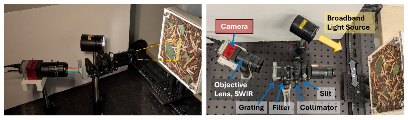
After constructing the FINCH EYE hyperspectral imager, UTAT will test and validate its performance on the ground before integrating it with the rest of the satellite. Some basic assessments include spatial resolution, modulation transfer function, spectral resolution, spectral responsivity, and spectral distortion; these measurements will be used to align and calibrate the imager. The next step is to measure some “realistic” samples – in our case, a mixture of soil, straw, and grass laid out in a container to emulate farmland – in a controlled laboratory environment. We’ll seek to validate our data processing pipeline and test its robustness to changes in soil moisture content and viewing zenith angle variations.
The testing campaign will culminate with a flight on an aircraft, where FINCH EYE will scan over farmland surrounding the Greater Toronto Area and collect raw data with solar glare and cloud scattering. Many hyperspectral imaging satellite payloads undergo such an airborne campaign as part of their qualification testing, together with shake and bake testing customary for any satellite application.
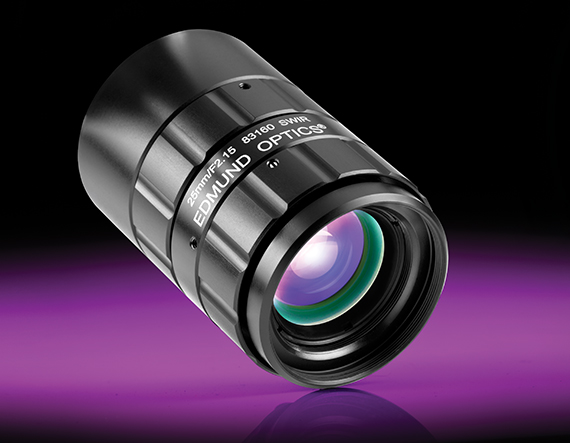 SWIR Series Fixed Focal Length Lenses
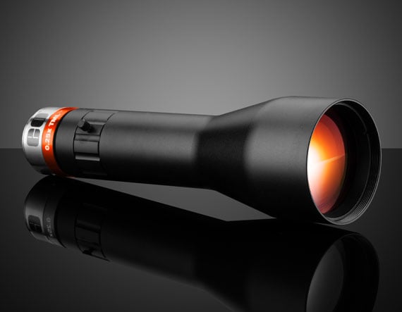 SilverTL™ SWIR Telecentric Lenses
 CCS SWIR In-Line Spot Lights


or view regional numbers
QUOTE TOOL
enter stock numbers to begin
Copyright 2023, Edmund Optics Inc., 14F., No.83, Sec. 4, Wenxin Road, Beitun District , Taichung City 406, Taiwan (R.O.C.)
Privacy Policy | Cookie Policy | Terms & Conditions | Accessibility
California Consumer Privacy Act (CCPA): Do Not Sell My Information
The FUTURE Depends On Optics®